- Modelo A3 - 32 cm (c) x 45 cm - inglês")
Informe seu CEP para calcular o valor da entrega.
Descrição
Detalhes
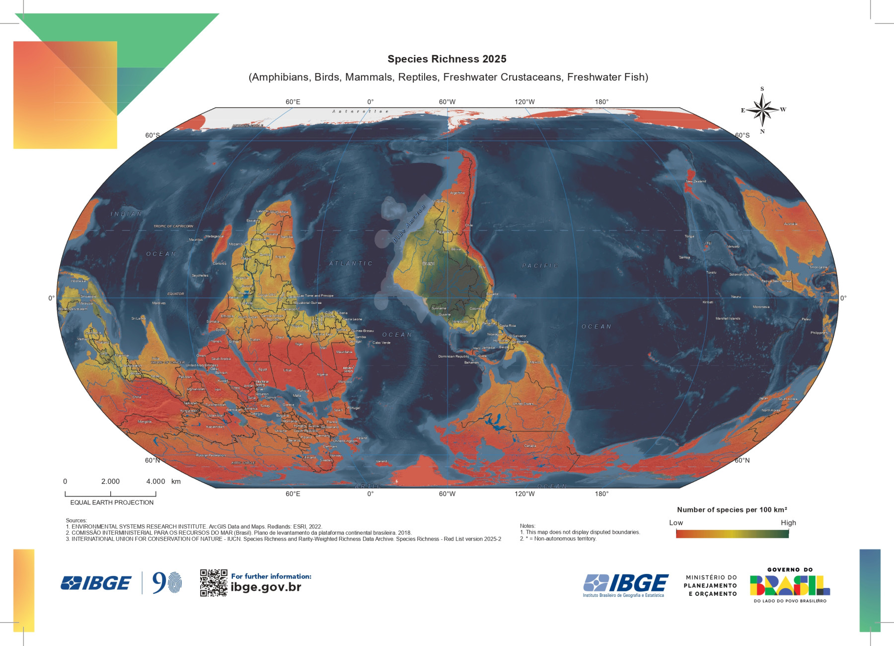
On May 22, International Day for Biological Diversity is celebrated. The date, established by the United Nations, honors the approval of the final text of the Convention on Biological Diversity, on May 22, 1992. The theme for the 2026 edition is “Act locally for global impact,” encouraging community actions and local practices, such as selective collection and conscious consumption, which create positive global impacts.
The date reinforces that the protection of biodiversity is essential for climate, food, and health, and seeks to raise awareness about the importance of fauna, flora, and ecosystems for the balance of life, health, and human well-being. The day is an opportunity to rethink the impact that we, humans, cause on the planet and to start adopting more sustainable attitudes.
To mark this date, IBGE releases the world map “Species Richness 2025,” which provides information about biodiversity around the world through the species richness indicator, which measures the quantity
Potential of species of amphibians, birds, mammals, reptiles, crustaceans, and freshwater fish that occur in each 100 km² cell. In terms of cartographic representation, the map features Brazil in the center, as a representation of its importance in the current social and political context; it presents the traditional North–South orientation inverted, as a reminder that there are different ways to view the world; and it incorporates the novelty of the Equal Earth cartographic projection. 2 – Continents in real proportions The Equal Earth projection is a modern projection that follows the curvature of the Earth and represents the continents in real proportions. It was created in 2018 by Bojan Šavrič, Tom Patterson, and Bernhard Jenny, with the main goal of providing a world map that did not distort shapes and maintained the equivalence of land mass areas, that is, that was visually pleasing and more realistic. Additionally, this projection seeks to promote a fairer and “decolonized” view of the world,
Correcting the Eurocentric bias present in traditional maps and serving as an educational tool and a more balanced representation. The Mercator projection, the most commonly used, was created in the 16th century by the Flemish cartographer Gerardus Mercator. Its purpose was to assist European navigators, allowing the plotting of straight-line routes on flat maps while maintaining a constant compass angle, which facilitated long-distance travel. However, this projection distorts continental masses, enlarging regions near the poles – such as North America and Greenland – and shrinking Africa and South America. In the Mercator projection, Greenland and Africa appear to be roughly the same size. In the Equal Earth projection, which presents the continents in their actual proportions, it would be possible to fit 14 Greenlands inside the African continent.
A3 format, front, color, glossy coated paper 115g
Informação Adicional
Informação Adicional
| Código | 000872 |
|---|---|
| Abrangência | Brasil |
| Mídia | Impresso |
| Escala | Não |
| Peso (Kg) | 0.1000 |
| Link para download | Não |
Comentários
Queremos saber sua opinião
Apenas usuários registrados podem comentar. Por favor, identifique-se ou cadastre-se
Produtos Relacionados
Escolha os produtos que deseja adicionar ao carrinho ou marcar todos


- Produtos Recentes

IBGE pelo Mundo 2025
R$30,00